Day 22, August 21
Pictured Rocks! WoW! But I get ahead of myself. Our destination today is Grand Marais which is about 40 miles from Murray Bay near Munising. We got underway at 7:00 and as we were pulling out of the cove, another sailboat, about the same size as ours, was leaving as well. Our route took us east northeast the entire way passing the Pictured Rocks National Shoreline.
I could write a book about all of the sites we marveled at but I am just going to include a number of pictures and say that if you want to see more and hear more, you will just have to come and see us back in Ohio. People had told me how beautiful this area is but their words and mine cannot do it justice. It is really neat. If you haven’t been there, I think that it is definitely a “Bucket List” place to visit. And, if you do come, you need to see it by water. There are a number of tour boats I haven’t counted but I would imagine I took a hundred pictures of the various formations.
 |
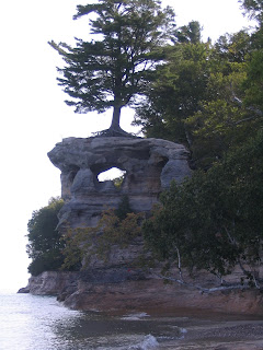
| Chapel Rock |
At a place called Chapel Beach, we decided to pull in and take a look at a water fall that was dropping into the lake. We motored in and dropped anchor at about 100 yards offshore. The water was about 9 feet deep and absolutely crystal clear. We took Dink in and beached her on the sand/gravel shore. We walked down to where the boat that left at the same time was backing up to the beach. He has a shoal draft boat which will allow him into very shallow water. He is from Sault Ste Marie and is heading home along the same route and itinerary as are we. As we walked the beach, he showed us agates and discussed the various marinas that we will be visiting. One of the outstanding sights from this beach is Chapel Rock. An amazing natural phenomenon. The water was so clear and I hadn’t bathed in a couple of days so I donned my bathing suit and took a cold water bath. It was really refreshing. We walked a ways along the trail that parallels the beach and ran into a number of serious day hikers. The trail that they were taking to get to where we were is about 10 miles long.
 |
| Big Hole |
Back out on the water, we watched a tour boat filled with passengers pull into what appeared to be a cave, completely disappearing. We had to try it. It turned out to be a eroded huge hole in a rock that was open at the top so we could pull all the way in and take pictures.
We continued our journey along this beautiful area and at Au Sable Point where a lighthouse had been erected, the landscape changed to a huge sand dune that extended for about 10 miles. At the end of the dune we came to our destination, Grand Marias. It is a well protected bay that provides save refuge from all directions. We pulled up to the fuel dock and took on 4 gallons of fuel. This will be the last fuel available for over 50 miles and we don’t want to be on the lake without a maximum amount of fuel.
 |
| Grand Sable Dune |
As we were finishing fueling, the research vessel, Lake Char, pulled up to the dock. We had first encountered her all the way back in Ontonagon then again in Copper Harbor, Lac La Belle, Marquette, and now in Grand Marias. I talked to them and their range is about where we saw her and she is studying lake trout.
We had a little trouble finding a place to drop our anchor. This is a deep harbor and the only shallow water where we can drop our hook is very close to shore. There are a number of mooring balls but they are all taken by the local folks. We finally found one place but were a bit uncomfortable about swinging into shallow water should the wind change direction.
We took Dink into the village and bought Ice and a cup of ice cream and then headed for bed.
 |
| Still Smiling after 21 days |
No comments:
Post a Comment